UN votes to adopt new world map to reflect Africa's true size

Because GMT is a thing?

A man made thing, AI has some interesting comments wrt eurocentric map design and who ran the world and dominated shipping back then.

Also consider that we usually count from 0 -> X and usually represent that as a line going from left to right, like a ruler etc, a map could easily start with GMT on the left with 360 being on the right. They could have picked GMT to be anywhere on the globe but it was chosen due to the royal observatory in greenwich and everyone else was already depended on british nautical charts so here we are today with europe in the middle. If say china ruled the seas, drew up the nautical charts etc our maps would look very different today. Ever seen those US classroom maps with the Americas in the middle?
 
No, not all politicians do this. Not every act deliberated by the UN or any body is superfluous and pointless.
It's these current hacks who are wasting money on this. Imagine the money and time wasted by these AU hacks and then in the UN to discuss this, not merely at the general assembly but over years of meetings and talks. This wasn't just a spontaneous act where one day someone put that on the agenda and they took 5 minutes to vote and that was that.

Time which could have been spent on fixing real African problems.

And then here we have guys who are confusing this map for GPS guidance and claiming it will fix car crashes. WTF?

It's pure ego stroking by African states. We want more aid and influence because we have a large land mass. We contribute relatively little but we want more only by virtue of our large land size. Ergo big countries matter more. It's a kind of supremacist thinking. It's not based on achievement or struggle against adversity, it's we are BIG! Respect us!

But nobody disrespects Africa because she is not seen as huge.

Secondly, this will cause a knock on effect of mass replacement over the coming years of perfectly good maps. Money wasted to reprint and resupply new wall maps for virtually every classroom in the world out there, maybe not every class has a world map hanging there, but most likely majority do. Those are all tax funds which will be wasted. Money wasted which could have been spent on important things. For what? For ego stroking of Zoomer and Millennial AU butt-hurt members.
No, obviously we need laws to protect us from the dummies and the dummies from themselves, but after the 1st few years, we should have all the laws needed to achieve this. Now fastforward a few centuries of politicians pretending to be busy (to avoid mob lynching and need to look busy earning those votes) by making new unnecessary laws and what we end up with is red tape paralysis.
 
No, obviously we need laws to protect us from the dummies and the dummies from themselves, but after the 1st few years, we should have all the laws needed to achieve this. Now fastforward a few centuries of politicians pretending to be busy (to avoid mob lynching and need to look busy earning those votes) by making new unnecessary laws and what we end up with is red tape paralysis.

Probably too off topic, but how would you change that?
About the only possible way that appears visible is Libertarianism, but it's too impractical. And the only other hope is mankind grows up... lol, can't see that happening any time soon
 

Second time you haven't been able to give an answer. Again I'll ask, more people live in China and SEA, why not advocate for that to be the centre. Why are the poor jungle Asians relegated to the corner of this inaccurate map, since we're be retarded wokes about this.

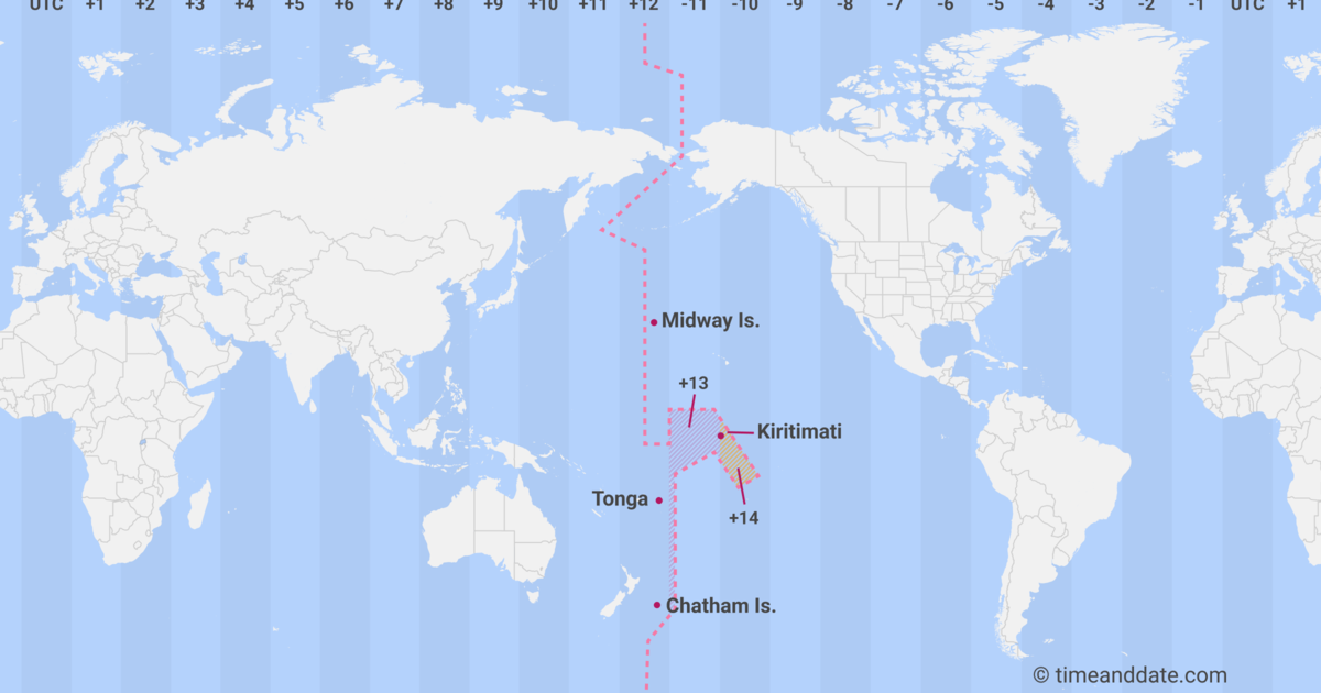
Not quite so simple. The majority of world maps are centered on the Greenwich Meridian (zero longitude), which happens to be close to Africa, and shows the inhabited continents in unbroken form. If you center a map on the International Date Line (180 longitude), it will be just as accurate, but break right through the continents. See:
international-date-line.png
 
Not quite so simple. The majority of world maps are centered on the Greenwich Meridian (zero longitude), which happens to be close to Africa, and shows the inhabited continents in unbroken form. If you center a map on the International Date Line (180 longitude), it will be just as accurate, but break right through the continents. See:
international-date-line.png

Side point
Whatever the reasoning, those islands are cheating, for tourism gain :- )
 
Last edited:
I've wondered about this because it doesn't reflect reality, I was caught out by this for most of my life up until quite recently because I just assumed all the maps in use in schools/universities/news reports must be an accurate reflection of the earths actual land surface area. Turns out I was wrong
You are very much not alone on this. This affects a ton of people.
 
Everyone is missing what is really happening here.

The UN "voted" to change this map and will soon require Africa to play a much bigger role in global decisions and rule.

This will enable the UN, WEF and European Commission to get closer to their aims of one global government or global rule.

These people are using black people and Africans to achieve their goals.
 
How is the new map "more accurate"?
Its more accurate in land area.

Greenland is the size of Argentina, not the size of Africa, lol. And most people who grew up staring at the Mercator map on a classroom/office wall don't actually understand that.
 
Last edited:
Everyone is missing what is really happening here.

The UN "voted" to change this map and will soon require Africa to play a much bigger role in global decisions and rule.

This will enable the UN, WEF and European Commission to get closer to their aims of one global government or global rule.

These people are using black people and Africans to achieve their goals.

Got some cheese for that cracker?
 
Probably too off topic, but how would you change that?
About the only possible way that appears visible is Libertarianism, but it's too impractical. And the only other hope is mankind grows up... lol, can't see that happening any time soon
Citizens get chosen by lottery system to serve government for 1 year like jury duty. This way corporates and evil billionaires can't influence/lobby career politicians with money during campaigning to adopt their evil plans with new laws.
 
Everyone is missing what is really happening here.

The UN "voted" to change this map and will soon require Africa to play a much bigger role in global decisions and rule.

This will enable the UN, WEF and European Commission to get closer to their aims of one global government or global rule.

These people are using black people and Africans to achieve their goals.

No, some here believe these are such power games or similar, a few posts going that way.

No shortage of smoke the last few years. And things like corporate abuse almost being seen as normal now, if you read the "right" sources.

No, don't want to discuss it.
 
Citizens get chosen by lottery system to serve government for 1 year like jury duty. This way corporates and evil billionaires can't influence/lobby career politicians with money during campaigning to adopt their evil plans with new laws.

@lexity ^^
:cool:


Not sure what we should do with the idjits that end up chosen though..
 
A man made thing, AI has some interesting comments wrt eurocentric map design and who ran the world and dominated shipping back then.

Also consider that we usually count from 0 -> X and usually represent that as a line going from left to right, like a ruler etc, a map could easily start with GMT on the left with 360 being on the right. They could have picked GMT to be anywhere on the globe but it was chosen due to the royal observatory in greenwich and everyone else was already depended on british nautical charts so here we are today with europe in the middle. If say china ruled the seas, drew up the nautical charts etc our maps would look very different today. Ever seen those US classroom maps with the Americas in the middle?
Yup, but at the end of the day, the centre point of a map needs to be decided some way. GMT may be arbitrary, but most of the world bases it's time zones on that standard. You could make the time zone centre anywhere you like, the trick is getting the rest of the world to change when GMT is already the standard and there is very little reason to change it.
 
This chirp only makes sense if it wasn't literally the reason coming out of African mouths at the UN. They wanted the change because their feefees were hurt that they looked smaller.
End of the day, both mercator and this new map make sacrifices because they are representing a globe on a flat surface. Good for you if you prefer the old map, but calling it woke is well...look at the picture ;)
 
Top
Sign up to the MyBroadband newsletter
X