See full forecast on our website for detailed information

snowreport.co.za
WARNING – DISRUPTIVE SNOWFALLS: Big snow on the way for SA, Lesotho and Namibia
8 July 2020
By Richard Le Sueur
Share via Whatsapp
A significant snowfall looks likely from Thursday night or the early hours of Friday morning for the Western Cape, Eastern Cape, Northern Cape, KwaZulu-Natal, the Free State, North West and Lesotho. Very light snow may also fall on the high-peaks in Namibia.
The South African Weather Service have warned that disruptive snowfalls are expected over the high-ground of the Cape Winelands on Friday and into Saturday morning. They have also issued a further warning of disruptive snowfalls in the western and southern high ground of the Northern Cape on Friday and into Saturday morning, which backs up our current forecast.
The data currently indicates that low-level snow that is accessible by vehicle is possible in some of these areas. While the snow is expected to be light at lower levels in most places, and as much as 40cm may fall on some of the high-peaks in the Western Cape. Snow is expected to fall through Friday and Saturday.
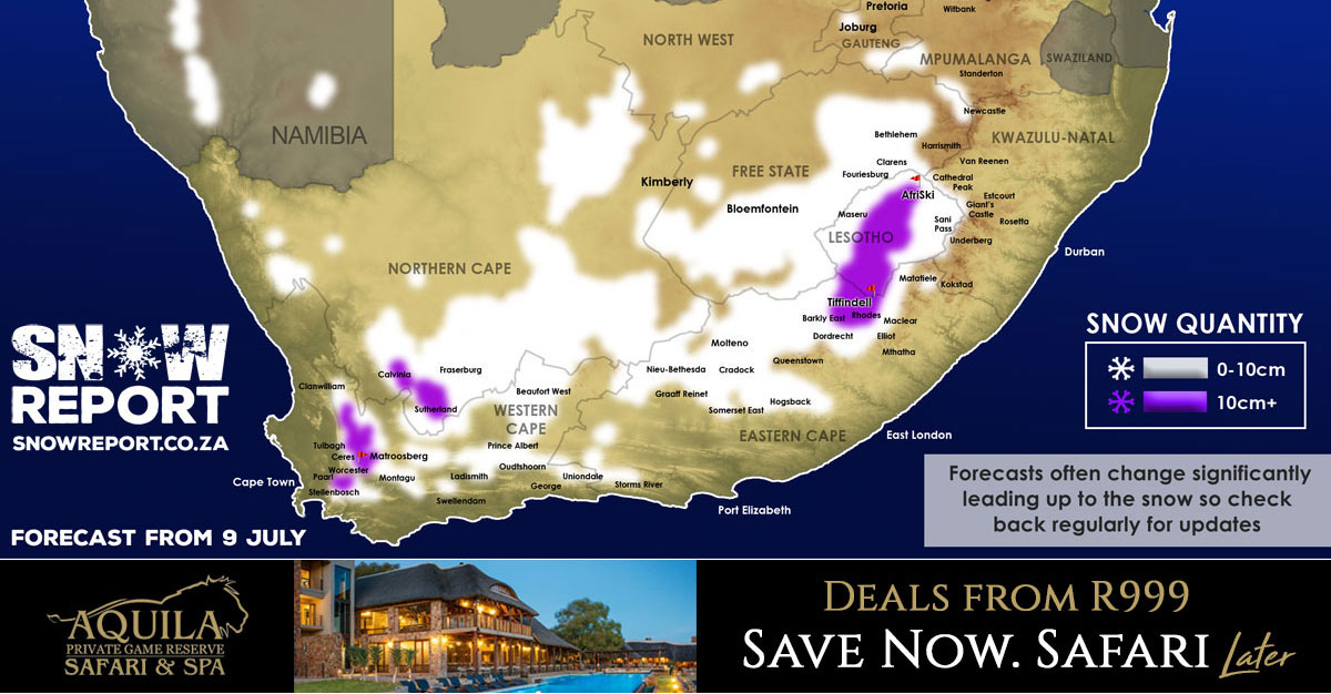
Here are the areas that are expected to get snow or where snow may be possible. The snow may either fall
in the town itself, but in most cases will be on the high-ground nearby or the nearby peaks, and therefore visible from these places. At this point though the freezing level could drop as low as 1250m in places, but this may still change.
In the Western Cape: Paarl, Stellenbosch, Franschhoek, Rawsonville, Worcester, Villiersdorp, Tulbagh, Wolseley, Ceres, De Doorns, Robertson, Montagu, Greyton, the Cederberg and the Koue Bokkeveld, Barrydale, Swellendam, Heidelberg, Riversdale, Ladismith, Calitzdorp, Oudtshoorn, Prince Albert, Beaufort West, De Rust, George, Uniondale and Willowmore.
In the Northern Cape: Sutherland, Calvinia, Fraserburg, Loxton, Postmasburg, Carnarvon, Springbok, De Aar, Colesberg.
In the Eastern Cape: Joubertina, Storms River, Graaff-Reinet, Nieu-Bethesda, Molteno, Sterkstroom, Cradock, Hofmeyr, Hogsback, Dordrecht, Burgersdorp, Aliwal North, Barkly East, Rhodes, Tarkastad, Seymore, Ugie, Elliot, Matatiele and many of the small towns nearby. Tiffindell Ski Resort is expected to get around 15cm of snowfall.
In the Free State: Clarens, Ficksburg, Fouriesburg, Bethlehem, Bloemfontein, Botshabelo, Ladybrand and many of the small towns indicated on the map.
In the North West: Klerksdorp and west of Vryburg.
In KwaZulu-Natal: If there is snow it will likely just be on the peaks in the Drakensberg on the Lesotho border, as per the map.
In Lesotho: Snow possible across the whole country, with the heaviest snow in the south-west. AfriSki is likely to get around 5cm of snow.
In Namibia: The mountains between Rosh Pinah and Aus, as well as north of Aus near Helmeringhausen, and around Karasburg.
The map indicates where SnowReportSA is currently seeing
the possibility of snow, but it may not fall in all of the areas shown on the map.
Another snowfall was indicated from
Monday for much of South Africa and Lesotho but at this stage the data is still very volatile. An further update will be posted by the weekend.
See full forecast on our website for detailed information
snowreport.co.za