-
- News
-
Categories
- 5G
- ADSL
- AI
- Banking
- Black Friday
- Broadband
- Broadcasting
- Business
- Business Telecoms
- Cellular
- Cloud and Hosting
- Columns
- Cryptocurrency
- Energy
- Enterprise
- Fibre
- Gadgets
- Gaming
- Government
- Hardware
- Industry News
- Internet
- Internet of Things
- Investing
- IT Services
- Motoring
- Reviews
- Science
- Security
- Smartphones
- Software
- Technology
- Telecoms
- Trending
- Wireless
- Press Office
- Forum
- Industry News
- What's Next
- Company hub
- Speed Test
- About us
- Advertise with us
- Contact
- Careers


-
Join the MyBroadband community
South Africa’s biggest forum. Discuss, discover, and connect with thousands of members.
-
Question of the Day: Have you ever ordered a product online and received a fake knock-off?

You are using an out of date browser. It may not display this or other websites correctly.
You should upgrade or use an alternative browser.
You should upgrade or use an alternative browser.
Rain and storm for Cpt
- Thread starter Draganchor
- Start date
- Status
- Not open for further replies.


dualmeister
Honorary Master
Please don't rain until later.
My daughter is playing her first hockey match.
My daughter is playing her first hockey match.

Geoff.D
Honorary Master
Farm in the Hanover district recorded 14 mm and then a further 5 mm plus hail. Hail not seen on the farm for 20 years.

Gordon_R
Honorary Master
NSRI involved in Breede River rescue:
 www.news24.com
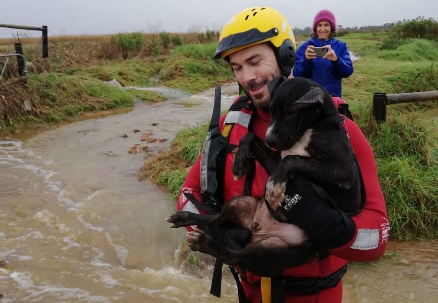
Western Cape storm: 45 farmworkers, and a dog, rescued from flood waters in Riviersonderend | News24
Forty-five farmworkers and a dog were rescued from rising waters as Riviersonderend flooded during a severe storm on Thursday.
www.news24.com
Gordon_R
Honorary Master
Further reports and closures:
/file/dailymaverick/wp-content/uploads/2021/05/Sandisiwe-winter-storm3.jpeg)
 www.dailymaverick.co.za
Rescue efforts continue in the Western Cape after winter storm strikes
Persistent rainfall has caused severe flooding in parts of the Western Cape. Evacuation and rescue efforts are ongoing as the storm moves towards the Garden Route where it is expected to weaken. …
www.dailymaverick.co.za

Gordon_R
Honorary Master
Looking forward and hopeful this realizes
View attachment 1066335
The models are very fickle. It will rain this weekend, but the amounts are hard to predict.

Nemus
Expert Member
- Joined
- Oct 12, 2012
- Messages
- 2,066
- Reaction score
- 2,063
I've seen that, yes. Simply in the fluctuations for Saturday where it started out as 10mm, peaked around 40mm and now at 18mm.The models are very fickle. It will rain this weekend, but the amounts are hard to predict.

oldBastard
Expert Member

The models are very fickle. It will rain this weekend, but the amounts are hard to predict.
Does it still make sense to still run your own weather station?
For me that lives in Tygervalley in a concrete jungle I suppose my microenvironment (Atmospheric pressure) should be different than a few kilometers from here.
IE, if I use an Arduino with a barometer, I should be able to forecast more accurately my own weather?
Gordon_R
Honorary Master
Does it still make sense to still run your own weather station?
For me that lives in Tygervalley in a concrete jungle I suppose my microenvironment (Atmospheric pressure) should be different than a few kilometers from here.
IE, if I use an Arduino with a barometer, I should be able to forecast more accurately my own weather?
Weather stations and forecasts are completely different things. A weather station tells you what conditions are right now. It cannot make any useful predictions.
Barometers were used to make forecasts in the 19th century, but only in the absence of anything else. Computer models now use thousands of inputs, from weather stations worldwide, as well as satellites, ships, aircraft, weather balloons etc.
Weather stations and forecasts are completely different things. A weather station tells you what conditions are right now. It cannot make any useful predictions.
Barometers were used to make forecasts in the 19th century, but only in the absence of anything else. Computer models now use thousands of inputs, from weather stations worldwide, as well as satellites, ships, aircraft, weather balloons etc.
Trying to say, if my data points are localized then my predictions (a separate program & algorithms I will write), should in theory be more accurate for my localized location?
(The goal is to learn more about the weather in the process)
Alternatively, can one feed weather information from a DIY station to the big forecasting organizations?
Geoff.D
Honorary Master
You should be able to establish a weather station that complies with SAWS specifications and register it.Trying to say, if my data points are localized then my predictions (a separate program & algorithms I will write), should in theory be more accurate for my localized location?
(The goal is to learn more about the weather in the process)
Alternatively, can one feed weather information from a DIY station to the big forecasting organizations?
And, whatever Gordon says, monitoring barometric pressure is still a very good indication of what the weather is going to do in the next say 2 hours provided you have a good grasp of the basic principles. But long term forecasting using local data is just about impossible.
Gordon_R
Honorary Master
Trying to say, if my data points are localized then my predictions (a separate program & algorithms I will write), should in theory be more accurate for my localized location?
(The goal is to learn more about the weather in the process)
Alternatively, can one feed weather information from a DIY station to the big forecasting organizations?
The key point is that weather collection is geographically dispersed, and readings from nearby stations do not provide statistically meaningful enhancement. If there were 50,000 backyard weather stations added in a given urban area, it would not make the forecasts any more accurate. If 50,000 weather stations were equally spaced around the world, that would be fantastic. Unfortunately 70% of the world's surface is water, so unless you own a fleet of ships or an aircraft, the data is not going to help much.
Due to circulation of the atmosphere, anything you measure now cannot influence the weather over your location for more than 3-6 hours. Any correlation that you find will mostly be with weather elsewhere, which is ultimately not useful.
Sorry to be so blunt, but that really is not how weather forecasting works, contrary to what manufacturers of weather stations may suggest in their marketing materials.
Gordon_R
Honorary Master
This morning's SAWS ship synoptic chart shows a large and complex frontal system positioned SW of CT. It will start to have effects on land from later this evening (Fri 14th), with an extended period of unsettled weather on Sat 15th. Winds are likely to be moderate, with heavy showers at time. There will be a sharp drop in temperature in the wake of the system.

Source: https://www.weathersa.co.za/images/data/specialised/ma_sy.gif
Source: https://www.weathersa.co.za/images/data/specialised/ma_sy.gif
Geoff.D
Honorary Master
Love the new colour coding on these synoptic charts!This morning's SAWS ship synoptic chart shows a large and complex frontal system positioned SW of CT. It will start to have effects on land from later this evening (Fri 14th), with an extended period of unsettled weather on Sat 15th. Winds are likely to be moderate, with heavy showers at time. There will be a sharp drop in temperature in the wake of the system.
View attachment 1068079
Source: https://www.weathersa.co.za/images/data/specialised/ma_sy.gif

Better be raining tomorrow morning, been waiting for a run in the rain at the forest for ages now.with heavy showers at time.


Vorastra
Honorary Master
Pretty hot in Durban at the moment.
- Status
- Not open for further replies.