


purple face
Honorary Master
When the rain hits you and its ice cold, you wanna rethink your next moveThe wind is a b|tch and forces a person to stay inside
South Africa’s biggest forum. Discuss, discover, and connect with thousands of members.
When the rain hits you and its ice cold, you wanna rethink your next moveThe wind is a b|tch and forces a person to stay inside

Its rained all night here by me and still raining and also freezing
![pwatr_018[20230423_1800].gif](https://mybroadband.co.za/forum/data/attachments/1452/1452515-c297448f6969f3eaa44d45521b7bfb19.jpg?hash=wpdEj2lp8- "pwatr_018[20230423_1800].gif")
![pwatr_024[20230420_0000].gif](https://mybroadband.co.za/forum/data/attachments/1452/1452513-bb822a31bc10ffb0177e0034f4b7a555.jpg?hash=u4IqMbwQ_7 "pwatr_024[20230420_0000].gif")


Just been out to empty the dustbin, check on the compost heap and empty the rain gauge. The wind has dropped, it is warm but very wet with 44 mm of rain in the gauge.I went outside now and was expecting it to be horribly chilly and it was actually quite warm, despite the rain still bucketing down.
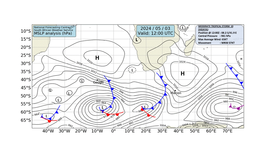
The difference between an atmospheric river and a cold front is not at all easy to show. SAWS is depicted below, which suggests that it is a confluence between last night's arrival of the cold front and the subtropical moisture flowing down from the north along the pressure difference. Today the synoptic chart shows that a rather weak high-pressure area is now present just inland to the east of CT. Compere that one with the chart taken at 12:00 UTC.
The High pressure area is now shown much further north and the next cold front is on its way.
This odd weather has made everything in my house a bit moist.

This odd weather has made everything in my house a bit moist.


Wooden and tile floors here feels sticky moist. Humidity inside up at 80%.This odd weather has made everything in my house a bit moist.

our councilor (yours as well) made a post the other day that many of these drains feed into the sewerage (illegally). So they are currently running tests where they smoke out the sewers to try and track these linked drains... keep an eye our for smoke coming up the pipes!According to tonight's TV forecasts, we are in for very heavy rain tomorrow starting in the early hours. I have diverted the rainwater out of the garden and back into the drains. ( I have no idea where the water goes when it flows into those drains though. The pipes don't empty into the road gutters anywhere that I can see. One day I might just try and trace the pipes. For all I know, they might all just couple up to the sewers.
Hah, first weather like this we are experiencing an a new house and I thought oh no, what the hell is wrong nowThis odd weather has made everything in my house a bit moist.


I thought maybe there was moisture coming through the roof somehow and stressing about having to fork out loads of money for repairs, lol.Hah, first weather like this we are experiencing an a new house and I thought oh no, what the hell is wrong now
Yeah its been raining nonstop hereThe stairs in our apartment block are completely soaked, floor, walls and ceiling. Even though the stairs are enclosed with only a few windows and doorway at the bottom.
Same. I just expect the worst and wonder how much it will cost. Also had the lights trip due to a seemingly dodgy outside light, but on the plus side, pool was nice and full on Saturday already.I thought maybe there was moisture coming through the roof somehow and stressing about having to fork out loads of money for repairs, lol.


